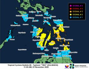
Tropical Cyclone Kalmaegi, locally known as Tino, has intensified into a typhoon as it further approaches Eastern Visayas, where Tropical Cyclone Wind Signal No. 3 was also being hoisted, according to the state weather bureau.
Kalmaegi packing with sustained winds of 120 kilometers per hour (kph) and gustiness of 150 kph, was located 285 km East Southeast of Guiuan, Eastern Samar, the Philippine Atmospheric Geophysical and Astronomical Services Administration (PAGASA) said in its 11:00 a.m. advisory.
The typhoon is moving southwestward at a speed of 25 kph and is likely to make its first landfall over areas of the southern portion of Eastern Samar, Leyte, Southern Leyte, or Dinagat Islands by Monday evening or Tuesday, PAGASA said.
“We expect that Tino will bring dangers or hazards such as heavy rainfall and strong winds that could cause flooding, landslides, and storm surges in areas directly affected by Tropical Storm Tino,” Nathaniel T. Servando, PAGASA’s Administrator, said during a press conference.
In anticipation of the effects of Kalmaegi, as of 11:00 a.m., PAGASA has raised Signal No. 3 in several areas where storm-force winds are expected, including the southern portion of Eastern Samar, the southern portion of Samar, the central and southern portions of Leyte, Southern Leyte, the Camotes Islands, the eastern portion of Bohol, Dinagat Islands, and the northern portion of Surigao del Norte, including Siargao and Bucas Grande Islands.
Signal No. 2, where gale-force winds are expected, is in effect over the southern portion of Masbate, the central portion of Eastern Samar, the central portion of Samar, the rest of Leyte, Biliran, the rest of Bohol, the rest of Cebu, the northern and central portions of Negros Oriental, the northern and central portions of Negros Occidental, and Guimaras.
It is likewise in effect over the eastern portion of Capiz, the northern and eastern portions of Iloilo, the rest of Surigao del Norte, the northern portion of Surigao del Sur, the northeastern portion of Agusan del Norte, and the northern portion of Camiguin.
Meanwhile, areas under Signal No. 1, where strong winds are expected, include Albay, Sorsogon, the rest of Masbate, including Ticao and Burias Islands, the southern portions of Quezon and Marinduque, Romblon, and the central and southern portions of Oriental and Occidental Mindoro.
The signal is also in effect over the northern portion of Palawan, including the Calamian, Cuyo, and Cagayancillo Islands, Northern Samar, the rest of Eastern Samar and Samar, Siquijor, the rest of Negros Oriental and Negros Occidental, the rest of Iloilo, the rest of Capiz, Aklan, Antique, including the Caluya Islands.
The state weather bureau also issued a storm surge warning for more than a dozen areas, noting that some may experience a high risk of life-threatening waves within the next 48 hours.
Storm surges with heights exceeding three meters are expected in several coastal areas of Dinagat Islands, Eastern Samar, Leyte, Western Samar, and Surigao del Norte.
Meanwhile, storm surges reaching 2.1 to 3.0 meters may occur along the coasts of Eastern Samar, Northern Samar, Southern Leyte, and Surigao del Norte, while surges of 1.0 to 2.0 meters are expected in coastal areas of Agusan del Norte, Aklan, Antique, Biliran, Bohol, and Camiguin.
PAGASA advised residents in affected coastal areas to stay away from the coast or beach and move to higher ground. It also recommended avoiding all marine activities amid the typhoon. — Edg Adrian A. Eva
