Fung-Wong intensifies into a severe tropical storm as it approaches PAR – BusinessWorld Online
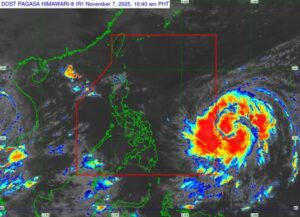
Tropical Cyclone Fung-Wong (international name) has intensified into a severe tropical storm as it continues to approach the Philippine Area of Responsibility (PAR), and may further strengthen into a super typhoon, according to the state weather bureau on Friday.
Fung-Wong, which will be locally named Uwan once it enters PAR, was packing maximum sustained winds of 100 kilometers per hour (kph) and gustiness of up to 125 kph, the Philippine Atmospheric, Geophysical and Astronomical Services Administration (PAGASA) said in its 11:00 a.m. advisory.
It was last located 1,315 kilometers east of Eastern Visayas, moving west-northwestward at 20 kph.
By Friday evening or Saturday morning, Fung-Wong is likely to enter the PAR, PAGASA said. It is also forecast to undergo rapid intensification, potentially reaching typhoon category within 24 hours, and possibly becoming a super typhoon by Saturday evening or Sunday morning.
At its peak intensity, it will likely make its first landfall over the southern portion of Cagayan or the northern portion of Isabela late Sunday evening or early Monday morning.
Fung-Wong is then expected to traverse the mountainous terrain of Northern Luzon and emerge over the West Philippine Sea by Monday morning or afternoon.
Up to Tropical Cyclone Wind Signal (TCWS) No. 5 may be raised in some of the affected areas, PAGASA said. The state weather bureau added that it will begin issuing warning signals by Friday afternoon or evening, likely over portions of Southern Luzon, Eastern Visayas, and Caraga, in preparation for the storm’s effects.
Storm surge warnings may also be issued in affected coastal areas by Saturday, particularly in Northern Luzon and along the eastern coast of Central and Southern Luzon.
PAGASA advised the public to continuously monitor updates on Fung-Wong as it approaches the country.— Edg Adrian A. Eva
